
Blog for Zipline Attraction in the Smoky Mountains
Located in Pigeon Forge, TN and near Gatlinburg and Sevierville.
Take A Hike-To Baskins Creek Falls!
By Ross Bodhi Ogle
Posted on February 14, 2017
The moderate temperatures we've enjoyed so much this winter have meant that many of us have been able to spend a lot more time outdoors than we normally might during this season. And since our Pigeon Forge zip line tours won't reopen for a few more weeks, we thought we would pass along an alternative suggestion for having fun surrounded by nature.
Of course, hiking in the mountains is one of the staples of outdoor recreation around here, particularly if you're taking on one of the dozens of trails in Great Smoky Mountains National Park. There are more than 800 miles' worth of trails to be explored in the park, and this week Smoky Mountain Ziplines would like to share our recent experience on one of them – the Baskins Creek Falls trail.
Our journey started by taking Historic Nature Trail Rd. (formerly Airport Rd.) from the Parkway in Gatlinburg and driving .7 miles to where Cherokee Orchard Rd. veers off to the right. We drove 2.2 more miles until we entered the one-way Cherokee Orchard loop and then .9 more miles to the entrance to Roaring Fork Motor Nature Trail.
However, that road is closed this time of year, so we parked on the shoulder of the road and walked .2 miles on Roaring Fork to the Baskins Creek Falls trailhead on the left. The first quarter-mile of the hike is moderately uphill and takes you through some of the charred devastation left in the wake of last fall's Gatlinburg wildfires. Most of the trees are scorched about halfway up, and the thinner rhododendron plants were left twisted.
Soon, the terrain leveled out and offered some fairly good views of nearby mountains. At the .9-mile mark, you'll have to cross Falls Branch creek, but the water was low, and there were several sturdy tree limbs placed across the channel, so we didn't have too much difficulty crossing. From there, the trail veers left and leads you along the creek, on a steady descent down the mountain.
As we headed downhill, we noticed that the fire-scorched terrain gradually gave way to the more natural character of the forest for this time of year. The deciduous trees were still bare, but the conifers were still green. Carpets of pine needles matted the ground in many areas, and we also noticed an early stretch marked by large outcroppings of quartz rock.
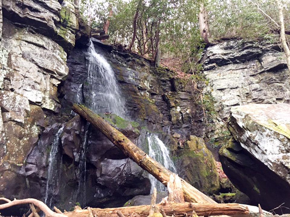
At 1.1 miles, the trail splits off to the left to go to Baskins Cemetery, but we stayed to the right to continue to the falls. At 1.3 miles, we approached another juncture and followed the sign to the left to continue to the falls. As you approach the falls, the trail becomes rocky, and you have to tread a little more carefully as you climb one final rise and then pick your way down the rocks to the base of the falls.
On the day we visited, the water flow was minimal, but the roughly 40-foot drop was still an impressive sight. We carefully followed a path of rocks out into the middle of the channel and sat near the collecting pool and watched the water cascade down for a while.
On the return trip, we paid the price for all that downhill on the way in by having to trudge slowly back up the mountain, stopping to take a few rest breaks along the way. But we still noticed things on the way back we hadn't noticed going in, and we wound up taking pictures of several sights that caught our eye – a salamander on a rock, an insect-infested tree stump, lichens on a fallen log.
The good news is that once we finally crested the ridge top, the last quarter mile or so was a piece of cake. The total round-trip hike was just a hair over three miles, so it can easily be worked into your vacation day. If you decide to try it out, have fun and enjoy safe hiking!


